The Rising Tide of Technology: Remote Sensing is transforming the Future of Fisheries
By Dr.Ambreen Afzal
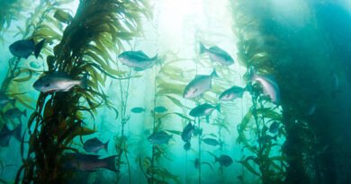
A fisherman rely on traditions passed down through generations, lunar cycles, shifting winds, and the hue of the water. Ocean rhythms were discovered via experience and read like a book for generations. But today, a revolution is sweeping across the world’s fisheries, quietly, steadily, from 700 km above our heads, as satellites high in space continuously monitor our oceans and guide modern fisheries with data that once seemed impossible to obtain.
This revolution is called remote sensing, and its role in the fisheries sector is no longer optional. It is essential.
According to the FAO’s State of World Marine Fishery Resources- 2025, the latest global assessment now evaluates the biological condition of 2,570 individual fish stocks, a significant expansion compared to earlier editions. Developed with input from over 650 experts representing more than 200 organizations across 90 countries, this inclusive and collaborative review examines patterns across every FAO marine fishing region. It offers the most comprehensive and recent knowledge on the health of the marine fisheries of the world.
The results indicate that 64.5% of the world fish stocks are within biologically sustainable levels but 35.5% are overfished. In consideration of the contribution to total catch, 77.2 percent of world fish landings are of stocks which are fished sustainably. Another benefit pointed out by the report is that an area with robust and efficient fisheries management is significantly better than the rest of the world.
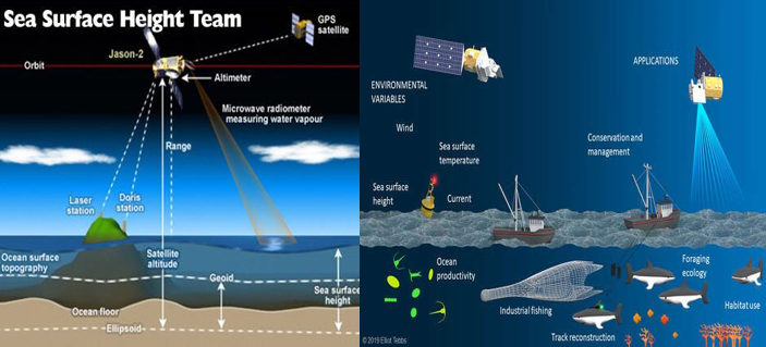
According to the FAO report, fisheries have numerous inherently spatial problems, fish move, water masses shift, areas of productivity increase and decrease. These spatial patterns could not be previously observed in the comprehensive way. They now are provided by satellites to a display, on a daily, hourly, or even every few minutes basis on certain systems.
A fisherman does not have to guess at all where cool waters blend with warm streams, where sardines, tuna and mackerel tend to congregate. These hotspots are located immediately via remote sensing.
A policymaker will no longer have to depend on the old stock appraisals. She is able to see live signals of ecosystem wellbeing such as temperature variations, algal blooms, coastal sediment loads automatically.
The fisheries industry that previously faced the challenge of poor and obsolete information now leads in the revolution of big data. Geographic Information Systems (GIS) used with remote sensing ultimately transforms millions of satellite-generated pixels into an effective instrument of real-time decision-making.
GIS combines remote sensing images with various layers of the vital information such as fishing grounds, habitat distribution, water quality, marine secured areas, aquaculture zones, and significant oceanographic condition. By integrating these diverse layers and analyzing them, managers can be able to determine the areas of fishing restrictions needed to preserve vulnerable habitats, determine the most ideal areas to develop sustainable aquaculture and how shifting species distributions due to climate changes are changing the historic fishing hotspots. This has been a dramatic contrast to the previous model of fisheries management that was most likely reactive, disjointed and lacked the speed to respond to new threats. The industry is now shifting towards the concept of precision fisheries, where decisions are based on spatial data of high-resolution, constantly updated, and not guesswork or delayed reports.
The remote sensing is vital in this undertaking by tracking the well-being of essential habitats like the mangroves and the coral reefs, identifying the early stages of stress like bleaching or excess sedimentation, and indicating the deterioration of nursery grounds upon which fish populations depend. It also allows one to identify pollution occurrences and harmful algae blooms by chlorophyll anomalies and suspended contents giving prior alert of red tides, and deoxygenation. Also, as climate change is causing a large-scale migration of many species to cooler latitudes, remote sensing is used to monitor these distributional changes so that countries can change their management policies in a timely manner. Governments would then be sailing in an ocean environment that is rapidly evolving as compared to the speed which traditional monitoring technology can keep pace with without these technologies.
In the case of coastal countries like Pakistan, which are blessed with more than 1000 km long coastline but are troubled by continuous data constraints, remote sensing has become a revolutionary tool. It can boost the fisheries sector in Pakistan significantly by determining the Potential Fishing Zones (PFZs), mapping hotspots of coastal pollution, tracking down of mangrove forest degradation, planning of sustainable aquaculture site, sustaining climate-resilient policies, and even identification of illegal fishing activities in real time. It is easy to envisage fishermen being notified by mobile alerts of satellite-derived PFZ maps, policymakers being able to follow the real-time tracks of trawlers entering the protection zones, or the investors in aquaculture relying on suitability maps that have been formed based on remote sensing analyses. This is no science fiction, it already exists in most areas of the world, and this work by FAO shows how many nations are already incorporating such technologies into national planning and governing the seas
Remote sensing is no substitute of the old wisdom of fishermen; it complements it. It honors generations of experience and gives the policymakers the clarity that they require to make informed decisions. With climate change redefining the marine ecosystem, as criminal activity endangers livelihoods, and with coastal ecosystems becoming more vulnerable, the industry can no longer afford to depend on old technology. The sky is now giving us a truly super powerful gift it brings us real-time views of what happens in our oceans. The issue is whether we decide to use it. The future of fisheries our food security, coast economies and biodiversity in the sea all lie with how ready we are to see, be daring and take wise measure. Remote sensing is not a technology of the future, but it is the breath of life.
Dr. Ambreen is a maritime professional specializing in GIS, remote sensing, and environmental geography, offering strategic insights on integrating geospatial intelligence into maritime operations and development planning.
The views and opinions expressed in this article are solely those of the author and do not necessarily reflect the views of Maritime Current News.